
Check environmental hazards near a Massachusetts address.
Explore flood zones, cleanup sites, drinking-water records and nearby infrastructure before you buy or rent. See the evidence and the questions to ask next.
Explore the map. Keep a useful brief.
The map, source records, place comparison and printable summary are free. An optional $40 Address Brief brings one confirmed location into a PDF delivered by email.
- Records within 5 miles with source dates and links
- Property, water and regional context with coverage limits
- A five-check action plan, clickable sources and copyable requests
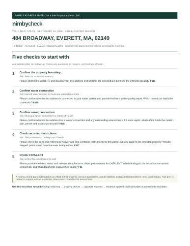 Preview the actual sample brief ↗One payment · no subscription · no account needed
Sex offender registry · town context
Loading published town totals…
Purple: historical count published Gray: count not published in this source. Colors show data availability, not danger.
Nearby source records
Parcel, utilities & recorded restrictions
Confirm the pin and parcel address. Service areas suggest a supplier; a utility connection and legal restrictions require property records.
Effects follow pathways, not the search circle
Air emissions
Wind, weather, stack height and terrain matter. Regional source pins extend beyond your search circle; they are not a modeled plume. No address-level air-dispersion model is loaded.
EPA modeled air-data methodology ↗Surface water & groundwater
The watershed outline shows a surface-drainage area. It does not establish an upstream connection or groundwater flow. For a cleanup site, request its actual plume, sampling and restriction maps.
Flood & noise
Parcel flood overlap uses FEMA polygons. Transportation noise has its own BTS modeled overlay. Neither follows a fixed distance from a facility or predicts conditions inside a building.
Regional air context
Air pollution follows wind, stack height, terrain and weather, so a facility well outside the circle can still matter. This section searches farther and across state lines. It is a search extent, not a danger radius, and none of it is a concentration at the address.
Flood, water, traffic, noise, radon
Other factors that shape a place decision, each from its own source and with its own limits. Measured, modeled and estimated information is labeled as such.
What agencies have documented.
Search US agency records for plate readers, Flock, facial recognition and other technologies. These describe agency use; they do not locate devices or establish current operation.
Local records and questions to ask
Explore the town's records, then check the address you are considering.
Help make the next property decision easier.
Try an address you know, then tell us what was useful, confusing or missing. Homebuyers, renters, inspectors and local researchers are welcome.
Share feedback or suggest a source ↗